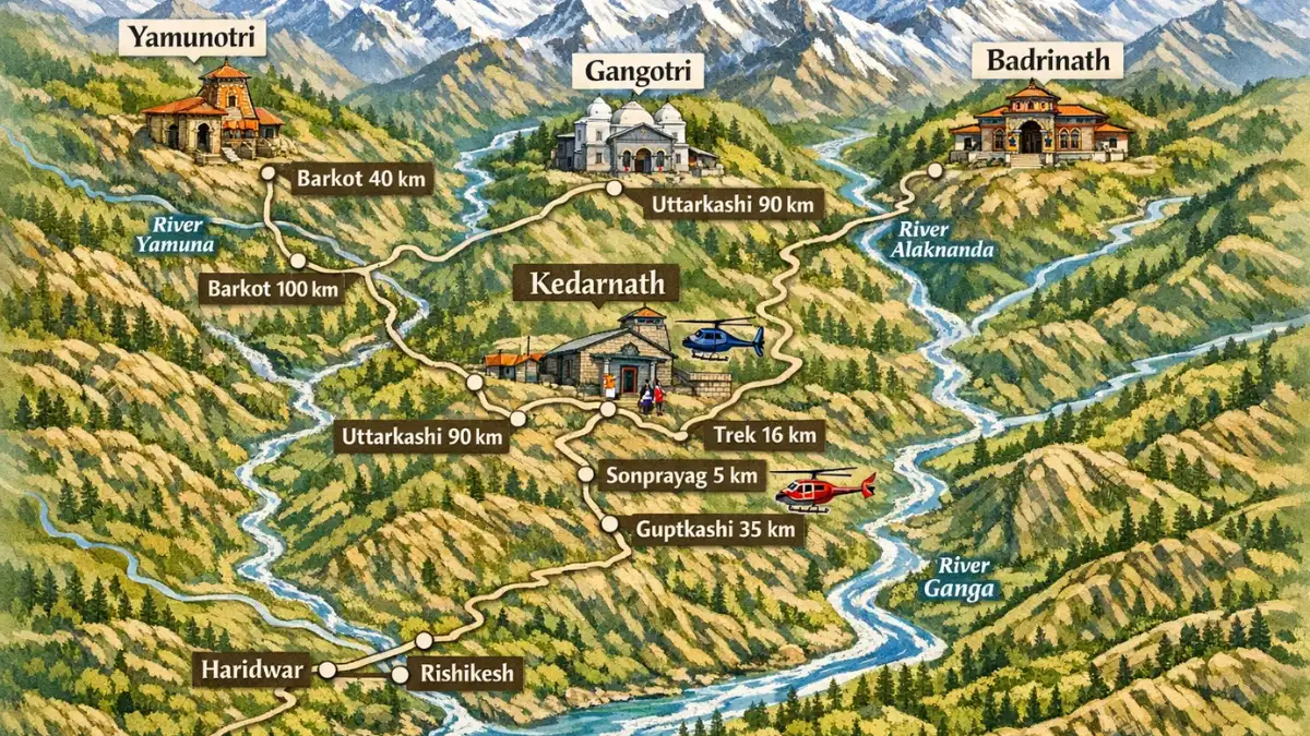
Chardham Yatra Route Map Explained Simply: Routes, Distance and Travel Flow
Chardham yatra route map is the first thing you should understand before planning your journey, because it shows the exact routes, distances and travel flow between all four dhams as this simple explanation of the chardham yatra route map helps you see where to start, which towns come in between and how long each stretch usually takes so whether you plan to travel fully by road or choose chardham yatra by helicopter for difficult or time-consuming sections knowing the chardham yatra route map clearly makes your journey smoother, safer and far less confusing.
Quick summary: the chardham yatra route map in one line
The traditional chardham yatra route map runs Yamunotri → Gangotri → Kedarnath → Badrinath, usually starting from Haridwar or Rishikesh. This order is the standard on most char dham in map guides and it keeps you on clear, widely used roads.
Official route order and why it matters
The official chardham yatra route map lists the four dhams as Yamunotri, Gangotri, Kedarnath, and Badrinath. Follow this sequence on your char dham route map to match local services, medical posts, and checkpoint rules, so your travel days flow without last-minute surprises.
Where to start: Rishikesh or Haridwar — which fits your chardham yatra route map?
Most pilgrims begin the chardham yatra route map from Haridwar or Rishikesh. These two towns connect easily to Delhi and are the last big service hubs on any char dham yatra map, so stock supplies, confirm hotel plans, and rest well here before you climb.
Route details and distances — practical chart from the chardham yatra route map
Here’s a clean char dham map with distance table you can use for day planning. Distances change slightly by road choice, so use these as good working estimates on your chardham yatra route map.
Leg (common) | Approx distance (km) | Typical drive time | Notes for your chardham yatra route map |
Delhi → Haridwar/Rishikesh | 210–230 km | 5–6 hrs | Highway to foothills; last big city services. |
Haridwar → Barkot (Yamunotri base) | 170–220 km | 5–7 hrs | Narrow mountain roads on your chardham yatra route map. |
Janki Chatti → Yamunotri (final) | 6–7 km trek | 3–5 hrs trek | Final stretch by foot or pony. |
Barkot → Uttarkashi → Gangotri | 80–200 km combined | 3–6 hrs per leg | Scenic but slow; keep buffer time. |
Guptkashi/Sonprayag → Kedarnath | Road + trek/heli | 6–9 hrs trek or short chopper | Helicopter options shorten your chardham yatra route map. |
Joshimath → Badrinath → Rishikesh | 290–300 km (return) | 9–11 hrs return | Final long drive back to plains. |
Keep this table handy as your working chardham yatra route map while you book stays and plan drives.
Two main route styles on the chardham yatra route map
On the chardham yatra route map people usually pick one of two styles depending on fitness and time:
- Road-first, trek-later: drive to base towns and use ponies or choppers for final stretches. This style fits families and older pilgrims and appears on many 4 dham yatra map examples.
- Slow mountain pace: shorter drives, overnight stays in small towns, and time for local sights. This relaxed style is best if you want rest and fewer long driving days on your chardham yatra route map.
Helicopter options and where they fit the chardham yatra route map
If you choose choppers, your chardham yatra route map changes. Helicopter services (seasonal) link heli-points like Phata and Sonprayag to Kedarnath, and sometimes to other bases. A 4 dham yatra route map with helipads will save days, but book only approved operators and plan road transfers to the helipads.
Road condition notes every chardham yatra route map must warn about
Roads on the chardham yatra route map cross steep valleys and river gorges. During monsoon you can expect landslides and delays. Keep a flexible plan and add buffer days to your itinerary. Local authorities often post live updates for the char dham road map; check them before each long drive.
Suggested 10–12 day sample itinerary using the chardham yatra route map
This balanced plan follows a typical chardham yatra route map and keeps drives reasonable.
- Day 1: Delhi → Haridwar/Rishikesh (rest).
- Day 2: Haridwar → Barkot (Yamunotri base).
- Day 3: Janki Chatti → Yamunotri darshan → Barkot.
- Day 4: Barkot → Uttarkashi (drive).
- Day 5: Uttarkashi → Gangotri darshan → Uttarkashi.
- Day 6: Uttarkashi → Guptkashi (long drive).
- Day 7: Guptkashi → Sonprayag → Kedarnath (trek or heli) → return.
- Day 8: Guptkashi → Rudraprayag → Joshimath.
- Day 9: Joshimath → Badrinath darshan.
- Day 10: Badrinath → Rishikesh/Haridwar return.
This sample chardham yatra route map can be adjusted if you want more rest days or plan chardham yatra by helicopter legs.
How to read a chardham yatra map with distance like a pro
Open any chardham yatra route map and first mark these things: base towns (Barkot, Uttarkashi, Guptkashi, Joshimath), trek/heli points (Janki Chatti, Gaurikund, Sonprayag), and the long hops (Badrinath → Rishikesh). If you treat your char dham on map as a set of manageable legs, you get realistic driving times and less stress.
Maps, apps and how to use a chardham yatra map offline
Signals drop on long stretches of the chardham yatra route map. Save an offline map or PDF of the char dham yatra map and keep a printed copy in the car. Use GPS apps for turn-by-turn but confirm road status with local police checkposts on the route.
Safety checklist tied to your chardham yatra route map
Before you leave with your chardham yatra route map, check these items:
- Road status and local weather alerts on the chardham road map.
- Vehicle greencard/trip card if using hired or commercial vehicles.
- Pilgrim registration printouts and ID copies.
- Emergency contacts and nearest hospitals along your char dham route map.
This small checklist keeps your trip steady and calm.
Final Thoughts on the Chardham Yatra Route Map Before You Start
Chardham yatra route map should always be your guide before you begin the journey because it helps you plan safe routes, proper rest stops and realistic travel days in the mountains so when you understand the chardham yatra route map clearly you avoid last-minute confusion and tiring detours so whether you travel fully by road or choose chardham yatra by helicopter to save time on long or difficult stretches following the chardham yatra route map carefully helps you stay relaxed, prepared and focused on the spiritual experience instead of travel worries.
FAQ — short answers from the chardham yatra route map
Is there one official 4 dham yatra map?
The Uttarakhand tourism layout is the standard chardham yatra route map, but local diversions can change short stretches. Always compare official sources with your 4 dham yatra map printout.
Can I drive to all four temples?
You can drive to base towns shown on your chardham yatra route map; the final stretch (Yamunotri trek, Kedarnath trek/heli) may need walking or chopper.
Where can I find a printable char dham in map?
Official tourism pages and trusted route guides publish printable char dham map with distance PDFs. Save them before you travel.
